Extracted text
Source-led transcription, lightly normalized from PDF p. 22; historical claims remain those of The Flaming Sword.
We are sometimes asked, Why if the earth is concave, have not geodesists encountered such facts as would suggest to them the idea of the concavity? In the articles already published in this department, on the subject of geodesy, we have shown wherein they have failed to apply the means of discovery of the earth's true contour. Depending, as they have, upon appearances and not upon facts of exact mechanical test, the fact of the earth's concavity has escaped them. But they have often met with difficulties which are inexplicable upon the basis of their assumption; they are well aware that something is wrong; but the public is not so well aware of the methods they employ to evade the same and to give their work the appearance of exactness. The people at large have come to consider the so-called science of geodesy of the present day to be the most exact science possible.
But such is far from being the case. When we come to compare the measures of meridional arcs made in various parts of the earth, the results obtained exhibit discordances far greater than what we have shown to be attributable to errors of observation, and which render it evident that the hypothesis (of flattened rotundity), in strictness of its wording, is untenable. —Herschel. These measurements are the most correct that perhaps have ever been made on the face of the earth. Men of the greatest skill have been employed ; instruments of the most perfect construction have been used ; every precaution has been adopted to avoid error, and all that science could do has been done.—Capt. Drayson, R. A.
After a century and a half of unsuccessful calculation, analysis is still seen toiling to invent empirical formulas for the purpose of establishing a tolerable accordance between the geodetic measurements of today and those of yesterday.—Von Gumpach. If, after science has done all it can do, it has failed to establish that for which it has so long been seeking—the shape and size of the earth; and if the exact form of the earth must be first obtained before astronomical calculations can be accurately made, where, we ask, are the proofs of the earth's convexity, and where is the accuracy usually attributed to astronomical "science"? The masses conclude that the measurement of the distance of the sun from the earth, made upon the basis of the "least squares," must surely approximate the true distance. But what are "least squares"?
If there are "least squares," may there not be "greater squares"? If the people were aware of the meaning of "least squares," their faith in the boasted accuracy of the old system would be greatly shaken. Geodetic "least squares," according to Webster, involve the "method of deducing, from a number of discordant observations of a phenomenon, the result most probably correct, namely, the result such that the sum of the squares of the difference between it and the several individual observations or results shall be the least possible.'' Thus, geodesists, finding very discordant observations coming in direct conflict, undertake to deduce a basis which shall be the sum of all their errors, and which is practically the establishment of an uncertain foundation for their so-called exact mathematical calculations of the size of the earth and the distance to the sun!
A Prominent Geodesist Notes Facts Which he is Unable to Account For. Geodesists do encounter facts which are antagonistic to the theory of convexity; but fertile imagination can always invent hypotheses with which to divert the mind from the proper channel of conclusion. If they meet with a difficulty which cannot be explained in accordance with known laws, it is attributed to some extraordinary freak of refraction; if they see twice as far over the earth's surface as the calculated convexity would admit, it is a mirage. So, inexplicable things in modern astronomy are attributed to some unknown power, thus putting all their ignorance in one mass and calling it God!
On the primary triangulation of the Great Lakes, three lines, respectively, 100, 93, and 92 miles in length, were observed across Lake Superior, which could not have been done except that the refraction was found sometimes to exceed twice its average amount. The line from station Vulcan, on Keweenaw point, to Station Tip-Top in Canada, was 100 miles in length. The ground at station Vulcan was 726 feet above the lake, and the observing station was elevated 75 feet higher, making 801 feet above the surface of the lake. The station at Tip-Top was 1523 feet above the lake, the observing tripod being only 3 feet high.
From the usual table of refraction, we find that the line of sight from Vulcan would become tangent to the surface of the lake at a distance of 37.4 miles, and that from Tip-Top, at a distance of 51.5 miles, thus leaving a gap of about 11 miles between the points of tangency, for ordinary values of refraction. If the interval were equally divided between the two stations, and these raised to the requisite height, we would find from the table, that Tip-Top would have to be elevated some 340 feet, and Vulcan, some 260 feet. Since this was not done, we must conclude that an occasional excessive value of refraction was sufficient to bend the rays of light by about these amounts in addition to the ordinary curvature from this source.
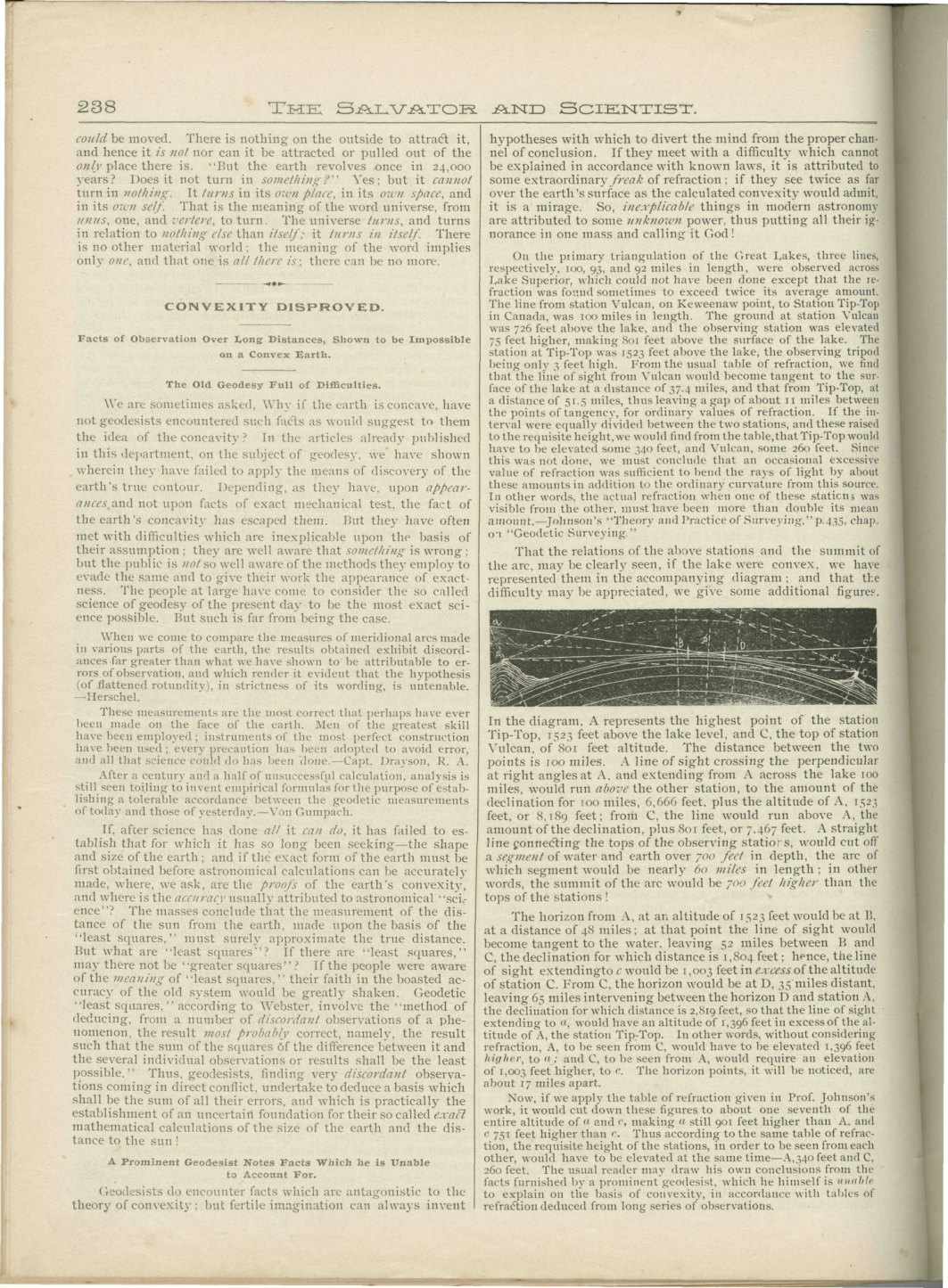
In other words, the actual refraction when one of these stations was visible from the other, must have been more than double its mean amount.—Johnson's "Theory and Practice of Surveying," p. 435, chap. 9, "Geodetic Surveying." That the relations of the above stations and the summit of the arc may be clearly seen, if the lake were convex, we have represented them in the accompanying diagram; and that the difficulty may be appreciated, we give some additional figures. In the diagram, A represents the highest point of the station Tip-Top, 1,523 feet above the lake level, and C, the top of station Vulcan, of 801 feet altitude. The distance between the two points is 100 miles.
A line of sight crossing the perpendicular at right angles at A, and extending from A across the lake 100 miles, would run above the other station, to the amount of the declination for 100 miles, 6,666 feet, plus the altitude of A, 1,523 feet, or 8,189 feet; from C, the line would run above A, the amount of the declination, plus 801 feet, or 7,467 feet. A straight line connecting the tops of the observing stations would cut off a segment of water and earth over 700 feet in depth, the arc of which segment would be nearly 60 miles in length; in other words, the summit of the arc would be 700 feet higher than the tops of the stations!
The horizon from A, at an altitude of 1,523 feet, would be at B, at a distance of 48 miles; at that point the line of sight would become tangent to the water, leaving 52 miles between B and C, the declination for which distance is 1,804 feet; hence, the line of sight extending to C would be 1,003 feet in excess of the altitude of station C. From C, the horizon would be at D, 35 miles distant, leaving 65 miles intervening between the horizon D and station A, the declination for which distance is 2,819 feet, so that the line of sight extending to A would have an altitude of 1,396 feet in excess of the altitude of A, the station Tip-Top. In other words, without considering refraction, A, to be seen from C, would have to be elevated 1,396 feet higher, and C, to be seen from A, would require an elevation of 1,003 feet higher, to C.
The Flaming Sword · Vol. 10, No. 10 · Oct. 1896 · PDF p. 22