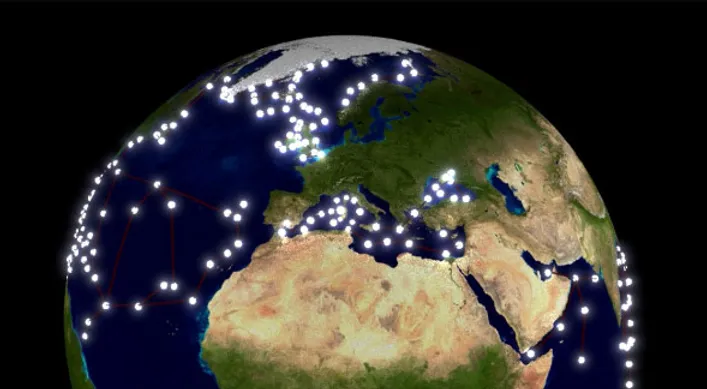
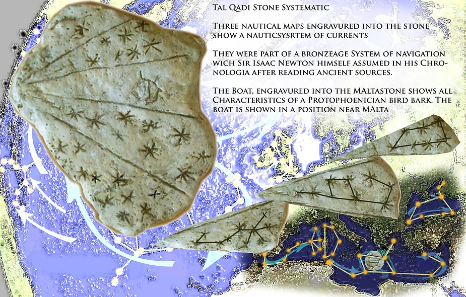
Renowned geografer and art historian Dr. Kai Helge Wirth has made a groundbreaking discovery that revolutionises our understanding of ancient Sumerian culture and its astronomical knowledge.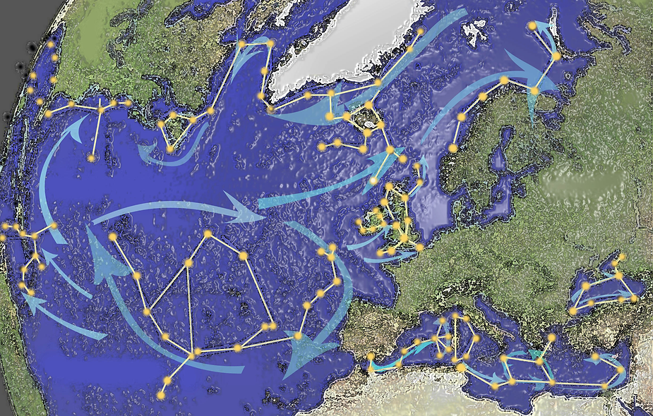 Through intensive research and observations of the night sky, Mr Wirth has identified a series of constellations that represent an astonishing correspondence between constellations and major sea routes used by the Sumerians thousands of years ago. This is no wonder, since the Sumerians themselves say the constellations (which they invented) are “ways of the ocean”.
The Sumerian civilisation, one of the oldest civilisations in human history, was known for its advanced knowledge of astronomy, mathematics and navigation. The discovery now reveals that the Sumerians created detailed maps of sea routes based on the positions of the stars thousands of years ago.
The identified constellations form a precise representation of coastlines, currents and navigation routes that enabled the Sumerians to travel safely through the seas and establish trade links. This astonishing discovery sheds new light on the skills and knowledge of Sumerian seafarers and shows how closely their navigational techniques were linked to observing the sky.
The Origin of Constellations
https://www.youtube.com/watch?v=D_W4Vpcw-QI
- 🌌 Ancient civilizations like the Egyptians, Sumerians, Babylonians, and Greeks passed down our current constellation patterns.

- 🐾 Explanations for constellations like Scorpio or Virgo representing animals are often unconvincing upon closer examination.
- 🌟 Instead of representing celestial discoveries, constellations were artificially configured for a different purpose.
- 🗺️ Stone Age cultures projected their coastal outlines onto the stars, creating constellations with astonishing precision.
- 🌍 These star maps perfectly match the coastlines from Norway to North Africa, including the Mediterranean and the Black Sea.
- 🏛️ Megalithic cultures, like those in Brittany, left behind impressive structures and evidence of advanced astronomical knowledge.
- 🚣♂️ Discoveries suggest early maritime navigation between continents, evidenced by boat constructions and engravings.
- 🛶 Experimental archaeologists have shown that megalithic cultures had advanced shipbuilding and nautical skills.
- 🌊 Reconstructions of Stone Age boats have demonstrated unexpected sailing capabilities, challenging historical assumptions.
Atlas in the Constellations Part 1
https://www.youtube.com/watch?v=KURo_w6Xk_Q
- 🌌 Ancient Navigation Hypothesis: “Today, I’ll discuss if ancient or Bronze Age sailors could map their familiar trade routes using star positions. Could they create sky maps to aid navigation?”
- 📜 Series Introduction: “This is part one of the series Atlas in the Stars, where I explore the system and the function of star patterns in ancient navigation.”
- 🌠 Are Stars Natural or Imagined?: “We know about 5,000 visible stars, but connections between them—constellations—are largely human-made interpretations.”
- ⭐ Constellation Analysis: “Some constellations, like Orion’s Belt, show natural alignment. But many others, such as Virgo or the Dragon, are purely imaginative connections.”
- 💡 Chaos of Constellations: “Following astronomer Herschel’s view, constellations might create more chaos than clarity, as their patterns aren’t inherently visible or natural.”
- 🗺️ Purpose of Constellations: “I’ll share a passage from the book Secrets of the Sky, which explores the role of constellations like the Argo ship in mythology and ancient guidance systems.”
- 📖 Book Excerpt on Argo Ship: “This ancient constellation, Argo, dates back to the Sumerians and symbolizes protection for sailors. It’s linked with numerous cultural myths about seafaring and guidance.”
- 🔍 Isaac Newton’s Contribution: “Isaac Newton even dedicated part of his Chronology to Argo, suggesting that such celestial maps aided ancient navigators.”
- 📚 Conclusion: “The cited sources offer rich insights, showing constellations as crafted for navigation, deeply rooted in history and myth, rather than random star groupings.”
Atlas in the Constellations Part 2
https://www.youtube.com/watch?v=MTFgGVtx8vo&t=129s
- 🌌 Introduction to Constellations: This video explores how constellations function and are mapped, tracing back to historical sources like the Sumerian Epic of Gilgamesh.
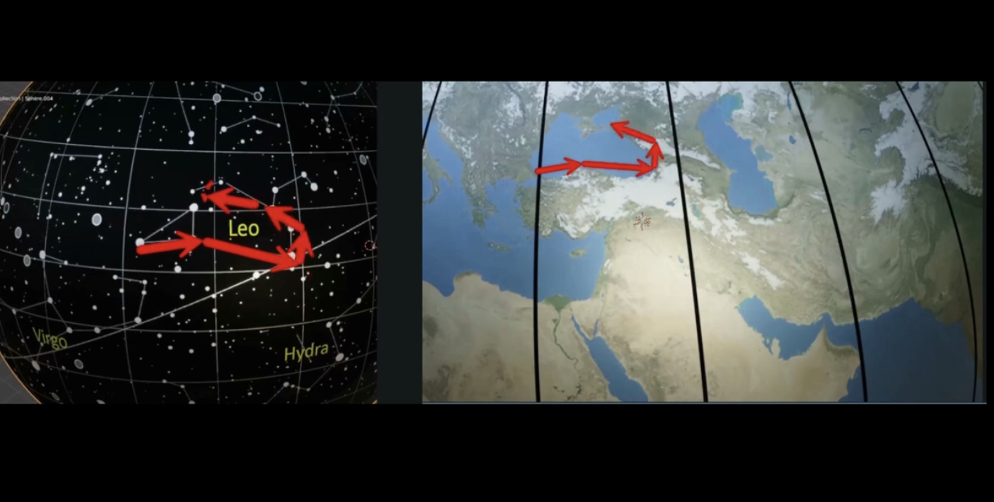
- 🌍 Earth-Centered Constellation Map: A map is presented showing Earth at the center, viewed from above, with Europe, Africa, and a conceptual Earth’s axis that aligns with Polaris.
- 🧭 Constellations Mirror Earth’s Geography: Constellations around the North Pole mirror Earth’s geography; for example, the Big Dipper aligns with northern areas like the North Sea and Norway.
- 🐉 Dragon Constellation: The Dragon constellation’s stars align with regions like Newfoundland and the Labrador Current.
- 🧩 Constellations Fit Like a Puzzle: The star formations fit Earth’s geographical features, creating a seamless “puzzle” that mirrors northern coastlines.
- 🔄 Link Between Sky and Geography: Constellations and Earth’s regions align, suggesting that historical peoples could use stars to navigate, particularly in the Northern Hemisphere.
- 🦁 Leo and the Black Sea: The Leo constellation fits near the Black Sea, further illustrating this geographical alignment.
- 🌍 Mediterranean and Zodiac Constellations: Mediterranean coastlines mirror zodiac constellations like Scorpio, Virgo, and Leo.
- 🐟 Pisces and the Pacific Ocean: Pisces aligns with the Hawaiian Islands, showing a link between the Pacific currents and the star patterns.
- 📖 Historical Constellation Mapping: This “constellation atlas” might have been used since the Bronze Age, possibly even earlier.
- 📚 Further Reading: For more details, check out the book Sternbilder – Seewege des Himmels, with an upcoming book also detailing the author’s journey and research.
Prehistoric revolution! The mystery of constellations – 2024 09 10
https://www.youtube.com/watch?v=f8yUsEW6WRU
- 🌌 Constellations’ Origins: Few people recognize constellations in the sky today, tracing back to the Sumerians who invented them 4,000 years ago.
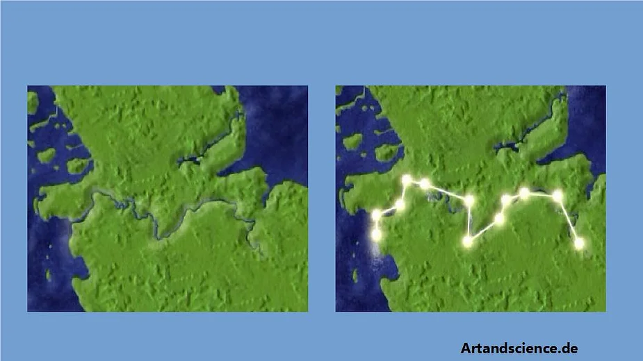
- 🌊 Mystery Deciphered: Research reveals that constellations may represent ocean currents and pathways, acting as a global navigation map.
- 🧩 Puzzle of Currents: Southern constellations align with southern ocean currents, while northern ones align with northern pathways, forming a puzzle-like structure.
- 🌍 Earth-Celestial Map Match: Each constellation matches specific Earth regions, mapping them in the sky according to their real-world location (north, south, west, etc.).
- 🚀 Prehistoric Revelation: This discovery suggests that the Sumerians or their ancestors had an advanced understanding of global geography.
- 📽️ Video Expansion: Future videos on this channel will aim to be bilingual (French and English) for broader accessibility.
- 👨🔬 Accessible Science: Dr. KT emphasizes clear science without jargon, allowing viewers to judge his findings for themselves through objective comparisons.
- 🖥️ Visual Proof: Animated comparisons between stellar and terrestrial maps help viewers see the similarities for themselves.
- 🙏 Viewer Appreciation: Dr. KT and his team express gratitude for viewers’ support and hope they enjoy the presentations.
Kai Helge Wirth: Autokinese
https://www.youtube.com/watch?v=w8AMLH88xb4
- 🌌 Criticism on Star Atlas Findings: There are critiques about the findings on the star atlas, especially regarding star formations.

- 💥 Misunderstanding of Star Movement: People often believe stars are moving apart due to the Big Bang, affecting their appearance over time.
- 📜 Effect Over Time: This movement only affects star formations over very long periods, not within the last 4,000–5,000 years.
- ⏳ Minimal Impact in Recent Millennia: In the time frame of the past 5,000–6,000 years, this movement has had negligible impact on star constellations.
- 🔄 Example of Changes Over Centuries: While significant changes would be evident over 150,000 years, short-term changes (like over 150 years) are minimal and don’t alter familiar constellations, like the Big Dipper.
- ✅ Conclusion on Critique: Although the concept is understandable, the timeframe discussed means star patterns have remained mostly unchanged.
Star Navigation
https://www.youtube.com/watch?v=1TuRGgsAaXo
- 🌌 Star Navigation Criticism: Some argue that navigating by constellations is imprecise, as it’s based on a large, generalized map rather than a precise tool.
- 🗺️ Atlas-Level Precision: The ancient navigational methods achieved a remarkable level of precision, yet aren’t exact enough for every coastal detail.
- 🌠 Stars as Guides: Despite limitations, enough stars are visible to allow practical navigation based on constellation patterns, aligning well with sea currents.
- 🤔 Contradictory Claims: Critics argue both that ancient maps were too imprecise for navigation and that ancient people were not skilled enough to produce such accurate maps, highlighting a contradiction.
The Meaning of the Constellations
https://www.youtube.com/watch?v=5Obd1CztC0w
- 🌌 Mysterious Constellations: The forms of constellations are challenging to identify in the night sky, which has an intriguing reason.
- 📜 Sumerian Origins: The Sumerians created the constellations, describing them as the “paths of the ocean” in their 4,000-year-old cuneiform texts.
- 🧩 Ocean Route Maps: A Frankfurt-based geographer recently decoded their true meaning, revealing constellations resemble potential ocean routes.
- 🔄 Puzzle of Currents: Not only do individual constellations look like specific current systems, but they also connect like a puzzle. Southern constellations mirror southern routes, northern ones align with northern courses, and eastern/western constellations match their earthly counterparts.
Draco and the Greenlandcurrents
https://www.youtube.com/watch?v=D-cQLZQLcHs
- 🌌 Northern Location: We’re positioned in the north of the sky, which corresponds to the very north of Earth.
- 🚢 Sky as a Map: The path from the North Sea to America aligns with the constellation Draco, potentially mirroring earthly sea routes.
- 🗺️ Celestial and Earthly Alignment: Celestial paths may have common reference points with earthly routes, showing similar complex shapes and notable landmarks like the Great Bear constellation.
- 🧭 Navigational Precision: Small deviations (a few degrees) don’t disrupt navigation; even something like a rubber duck would follow currents to arrive accurately.
Dr. Kai Helge Wirth historische Quellen zu den Sternbildern
https://www.youtube.com/watch?v=o6unPCEJhPw
- 🌌 Ancient authors associated seafaring with navigation and constellations.
- 🚢 The Argonauts’ saga highlights sailors using stars like Orion for navigation at sea.
- 🌠 Stars, particularly Orion and the Dipper, played crucial roles in ancient navigation theories.
- 🗺️ Ancient maps, possibly influenced by celestial navigation, aided post-flood seafaring.
- 🌊 Sumerians viewed constellations as celestial waterways, connecting them with their water god, Ea.
Hot Stuff, ancient Eridanus ist not Italian river Po! Old misconception finally corrected
https://www.stoneagenews.com/post/hot-stuff-ancient-eridanus-ist-not-italian-river-po-old-misconception-finally-corrected
- 🌊 One of the constellations is called Eridanos, derived from the Greek word “Danos” meaning river, hence “River Eri” or “Erid”. Earlier, it was thought to represent the River Po in Italy.
- 📜 The river Eridanos is mentioned by Hesiod, Herodotus, and other ancient Greek sources, with specific details.
- 🌍 Facts:
- “Eridanos lies north of the land of the Hyperborean peoples in the far north and this river should be able to flow upwards.”
- “Amber is found in this river.”
- “The river flows north into the ocean.”
- 🏞️ The Eider River in Schleswig-Holstein, formerly in Denmark (Vikingland), fits all these descriptions: it flows upstream at high tide, was a major source of Bronze Age amber traded to Egypt via the Amber Road, and flows into the northern European ocean.
- 🌌 Now consider the projection: Eider and the constellation Eridanos share striking similarities.
- 🚢 Tacitus mentions cultural aspects around the Eider, including worship of the goddess Isis and burial practices for kings.
- 🌌 In the 12th century, the constellation Eridanos was significantly enlarged southward by an Arab astronomer, altering its original shape.
BONUS
Sacred geography and the ‘sky map’
It also appears the ancients constructed dolmens along the coastlines where there are high amounts of telluric currents. The topographic geometry of these megaliths echo the patterns in the starry sky. What is above is literally also below.
via: allaboutheaven.org
“Ley lines and sacred sites are connected, and can be found all over the earth. Superficially they appear simply to connect points on the surface of the earth that have been chosen because they are the focus of strong telluric currents. They are sacred because they help with spiritual experience. But telluric currents have a cause and the cause is the combination of the magnetic forces under the earth’s surface interacting with the planets and other heavenly bodies in the sky. What is above influences what is below a great deal.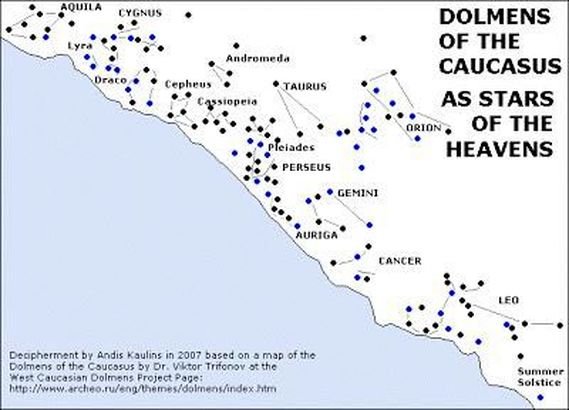
Alfred Watkins, the pioneer of the discovery of ley lines in the UK, found that some stones had maps of the ley lines on them [see cup and rings]. Yet others have noted that stones such as the dolmen of Rocenaud, France, has cup marks which are grouped to resemble the Pleiades.
By deduction, others have now worked out that cup marked stones are BOTH ley maps AND Constellation maps. They diagrammatically represent a star constellation, but at the same time that star constellation has been physically marked out on the earth, using sacred sites, mark stones, ley lines, and so on with the exact proportions that occur in the constellation – as above so below.
We can thus state that Sacred geography is representing heaven and its constellations here on earth.”
http://www.ancient-wisdom.com/russiadolmen.htm
http://www.ra.iaran.ru/?page_id=2001&lang=en
https://www.ancient-origins.net/ancient-places-europe/mysterious-dolmens-caucasus-001766#!biiHfO
Discover more from JoeDubs
Subscribe to get the latest posts sent to your email.
