Extracted text
Editorial transcription, lightly normalized from the scan. Line-break hyphenation, spacing, capitalization, and unmistakable OCR errors have been repaired; the claims remain those of The Flaming Sword.
The Geodetic Survey.
Demonstration of the Earth's Concavity the Inevitable Result.
The Air Line Gradually Descending to the Water Level at the Proper Ratio.
The earth is concave! This truth Koresh has proclaimed to a skeptical world for over a quarter of a century. That which the scientists of the present age have considered to be unworthy of notice is now about to become tangibly manifest in absolute demonstration. Evidences as eternal as the universe are about to be forced upon the world. In this age of the prevalence of fallacy, when the central key of life and knowledge is lost to the inhabitants of the great cellular form, the contour of the earth is made to declare the Truth. The testimony of its own curvature, of its own form, is at last appealed to in substantiation of the claims of Koresh!
We are ready to satisfy all those who have asked for proofs and evidences of the earth's concavity. For some time, thousands who have learned of our purpose of demonstration of the premise of the Koreshan System, have been anxiously awaiting the results of the Geodetic Survey on the west coast of Florida. We have had the courage to pivot the system upon our propositions, and to make a practical application of the principles involved therein. Some of our friends have been solicitous for us, fearful, perhaps, that the evidences should be against us.
"Will you stand by the result?" we have been asked from all quarters. Many have written us that it is well to produce the evidences, to make the demonstration, but not best to say too much about it until it is done! Koresh has seen fit to pursue a different course, and has again and again emphatically declared what the result would be. Readers of THE FLAMING SWORD are fully aware of the positive character of his statements. The world will yet realize the truth of the Cellular Cosmogony—they will yet actually see the arc of the earth's concavity, and be satisfied! Concerning the result of our work, we call to mind the closing paragraph of the article, "The Bible, Is It True or False?" in the October, 1896, SWORD:
"Follow, through careful perusal of the physics department of THE FLAMING SWORD, the reports and explanations of experiments made by the Astronomical, Geodetic, and Civil Engineering Staff of the Koreshan Unity, for the physical, mechanical, and mathematical proof of the unity of science, in the rendering of nature and Scripture into the unified language of human comprehension."
The evidences presented in the March number of the SWORD have had the desired effect. The Geodetic Staff, operating on the Gulf coast of Florida, has already demonstrated the earth's concavity; but the climax is to be reached in the "air line," surveyed by means of the Rectilineator, as the chord over the concave arc of the hollow sphere. This geodetic work is in progress; about 1⅞ miles have been surveyed, the air line is gradually going down at the proper ratio, and the levels indicate a deviation from the horizontal decidedly in favor of our anticipations.
Modus Operandi of the New Geodesy.
On March 18, upon the Gulf coast at Naples, Fla., three miles north of Gordon's Pass, the air line was begun. The first section of the Rectilineator was placed upon its standards with its middle line or horizontal axis just 10 feet above the water level. The ground elevation at place of starting is about five feet below the beginning of the line of survey. At 8:40 a.m., on the morning of the 18th, Section 1 was pronounced level, after the application of very fine spirit and mercurial levels; plumb-line was also applied to the four-foot cross-arms at right angles to the plane of the horizontal, and upon observation, with the eye at the proper altitude, the lower edge of the long mahogany straightedge was exactly parallel to the distinct horizon line upon the Gulf. Thus practically, four tests of level and plumb were applied with the same result. At 8:50 a.m., the first adjustment was made, and the survey of the airline was commenced. As has been described before, the survey consists in mechanically forcing a straight line, practically building the line by the precise adjustments of the brass-facings placed at absolute right angles to the horizontal axis of the apparatus. After section 2 is carefully adjusted to Section 1, No. 3 is adjusted to the forward end of No. 2, when Section 1 is detached and likewise adjusted to the forward end of No. 2, and so on throughout the line of survey.
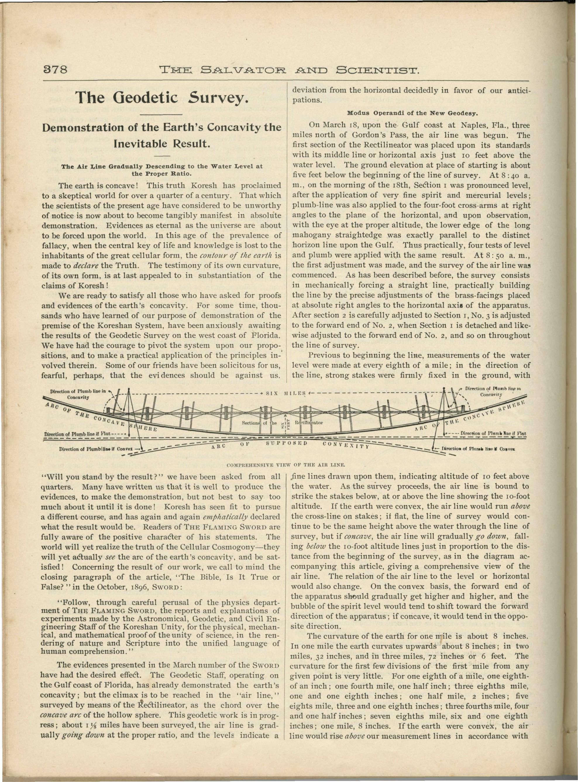
Previous to beginning the line, measurements of the water level were made at every eighth of a mile; in the direction of the line, strong stakes were firmly fixed in the ground, with fine lines drawn upon them, indicating altitude of 10 feet above the water. As the survey proceeds, the air line is bound to strike the stakes below, at or above the line showing the 10-foot altitude. If the earth were convex, the air line would run above the cross-line on stakes; if flat, the line of survey would continue to be the same height above the water through the line of survey, but if concave, the air line will gradually go down, falling below the 10-foot altitude lines just in proportion to the distance from the beginning of the survey, as in the diagram accompanying this article, giving a comprehensive view of the air line. The relation of the air line to the level or horizontal would also change. On the convex basis, the forward end of the apparatus should gradually get higher and higher, and the bubble of the spirit level would tend to shift toward the forward direction of the apparatus; if concave, it would tend in the opposite direction.
The curvature of the earth for one mile is about 8 inches. In one mile the earth curvates upwards about 8 inches; in two miles, 32 inches, and in three miles, 72 inches or 6 feet. The curvature for the first few divisions of the first mile from any given point is very little. For one eighth of a mile, one eighth of an inch; one fourth mile, one half inch; three eighths mile, one and one eighth inches; one half mile, 2 inches; five eighths mile, three and one eighth inches; three fourths mile, four and one half inches; seven eighths mile, six and one eighth inches; one mile, 8 inches. If the earth were convex, the air line would rise above our measurement lines in accordance with this ratio; if concave, the air line would fall below the measurement lines in about the same ratio. About one and one eighth miles have been surveyed, and what is the result?
Gradual Descent of the Air Line.
The measurements above the water have been made with as much care and accuracy as possible. Very slight fluctuations, even in the tide registers and in the pools, and the capillary effect of the wood surface extending into the water, make absolute measurements impossible—we cannot get down to hundredths of an inch by these means, but approximately to eighths of an inch. That our measurements and survey have been remarkably accurate, may be seen from the following reports of the facts and results obtained as the work of the survey has progressed:
Not until about 400 feet had been passed over was there manifest any deviation from the level obtained at the starting point. At adjustment No. 37, the spirit level was applied, with the bubble slightly shifted toward the starting point of the survey. The angle was very slight, and just observable by means of test by level, and by observation of the relation of the long straightedges to the horizon line on the Gulf. From that point until the time of present report, the deviation has grown more and more marked, and the angle has gradually increased. At adjustment No. 55, at the end of the first eighth of mile, or 660 feet, record stake No. 2 was reached. Our expectations were realized here upon observation of the horizontal axis of the apparatus — ⅛ of an inch below the measurement line upon the stake. The difference was very small, but at the proper ratio, giving strong testimony as to the accuracy of the line surveyed by the Rectilineator, as well as foreshowing what the result would be in the end!
At adjustment No. 110, record stake No. 3 was reached, bearing the line indicating 10 feet above the water, as per our system of tide registering. Below this line, the central line of the apparatus was observed to be about one half inch. At this point level was applied, with the same results as before. Likewise, at adjustment No. 165, at end of survey of three eighths of mile, the air line was one and three eighths inches below the measurement line on record stake No. 4. At adjustment No. 220, the end of the first half mile was reached, with the line of survey two inches nearer the water than at starting point, while adjustment No. 275 brought us to the end of five eighths of the first mile, with the horizontal axis of the Rectilineator a little over three inches below the measurement line on record stake No. 6. At end of three fourths of mile, the line was down four and three eighths inches; seven eighths of mile, six and seven sixteenths of an inch. When the end of first mile was reached, the medial line of the apparatus was observed to be 8.02 inches nearer the water's surface than at beginning of survey; and in about the proper proportion the line was below altitude of starting point, as indicated upon stake at end of one and one eighth miles; there the line was observed to be 10¼ inches nearer the water than at commencement of the rectiline. At the end of 3 miles, we will have reached the point where the water's surface has curvated upwards 6 feet, and the horizontal axis of the apparatus will be only 4 feet from the water's surface; we started with the air line 10 feet above the water. We are now surveying about one eighth of a mile per day; at this rate of progress, we will complete the first line of survey about April 20. When Gordon's Pass has been reached, the great scientific "Gordian knot" will have been severed, and the fundamental premise of the Koreshan Cosmogony will have been absolutely demonstrated!
This work of demonstration of the earth's concavity is the beginning of the stupendous scientific revolution. With the demonstrated facts as the foundation of an integral system, KORESH will march steadily onward to victory over fallacy. Ere the scientists will take time to realize the importance of the work of Koresh, thousands and thousands who have hitherto been blindly led by the gross errors prevailing today, will accept the facts presented to them, and the System which they support. When the scientific leaders of today awake to their mistake, they will find that their energies and opportunities have slipped away into more worthy hands for a more worthy and noble purpose than contributing to the false honors the modern scientists have bestowed upon themselves. The great scientific campaign has begun, and the contest and warfare of Truth and fallacy will be waged until Truth becomes the victor in the great conflict!
The Flaming Sword · Vol. 11, No. 4 · Apr 1897 · PDF pp. 18–19
The Flaming Sword · Vol. 11, No. 4 · Apr 1897 · PDF pp. 18-19