Extracted text
Editorial transcription, lightly normalized from the scan. Line-break hyphenation, spacing, capitalization, and unmistakable OCR errors have been repaired; the claims remain those of The Flaming Sword.
Geodesy is the application of mechanical and other means of determining measurements of the earth's surface, including not only that of its general contour as to whether it is concave, flat, or convex, but also of demonstrating the amount of curvation at any given point and in any given direction.
The Copernican system of astronomy assumes that the earth's surface is convex, and upon this assumption the Copernican system has been fabricated. No astronomer has ever yet presented any proof of the Copernican system; and one of the persistent efforts of the modern physicist is to find some irrefragable proof of what every so called astronomical scientist knows to be merely an assumption.
The Koreshan System of astronomy is in direct opposition to the Copernican system, and unlike the Copernican system it is founded, not upon an assumption, but rather upon a premise so absolutely within the sphere of mechanical demonstration as to place it beyond and out of the uncertainty of mere postulation, which we assert to be the basis of so called modern science.
HORIZONTAL RECTILINEATION.
Heretofore, the common method of attempting the determination of a straight horizontal line has been by the use of the theodolite. There are a number of optical factors not taken into consideration by the geodetic surveyor and civil engineer, which render it impossible to extend a horizontal rectiline by the aid of optical instruments. The theodolite is an instrument used by the surveyor, and includes a compass and small telescope usually placed on the top of a tripod. This is more especially employed for the measurement of angles. The telescope, with a spirit or other level placed upon the tripod without the compass, is generally preferred. This is the transit instrument.
IT IS IMPOSSIBLE TO EXTEND A RECTILINE ACROSS THE TOP OF AN EXTENSION OF POLES OR MASTS, EITHER WITH THE TRANSIT INSTRUMENT OR THE NAKED EYE.
It is a fact not generally known, that it is impossible to determine a horizontal rectiline with a transit instrument, or by the unaided eye, along the apex of successive heights of a given elevation, or along a continuously extended surface. The scientific reason for this impossibility resides in the fact that in the determination of a horizontal or lateral rectiline, an impression made upon the retina of the eye by a picture from one side of a visual direction must be counterbalanced by an equal picture on the opposite side, and the geodetic engineer, not being acquainted with this law of obtension in optics, extends a curved line while he believes he is continuing a rectiline.
NO TWO MEN OF DIFFERENT HEIGHTS CAN, WHILE ADJUSTING THE TRIPOD TO ACCOMMODATE THE DIFFERENCE, EXTEND A LINE OF THE SAME CURVATION.
A civil engineer six feet tall—adjusting his tripod to conform to his height—will make a curved line, by the aid of his instrument, upward of a given curvation, while the man five feet six inches tall, adjusting his tripod to suit his height, will determine a curvation of a lesser curve proportionably to the difference in height of the adjustment. The scientific cause for this discrepancy resides in the optical illusion referred to above, namely, that on one side of the visual line there are two factors entering into the formation of a picture on the retina, as follows: the perpendicular post producing the effect of retinal impression, is shortened or elongated proportionably to the distance of the object in perspective, and in addition to this the geolinear foreshortening (the line along the earth's surface) induces a corresponding effect upon the retinal membrane. We confront, then, two species of foreshortening—the one geolinear, the other perpendicular—in all geodetic observations; and an optical phenomenon which should be attributed to the principle of perspective foreshortening is ignorantly attributed to curvation.
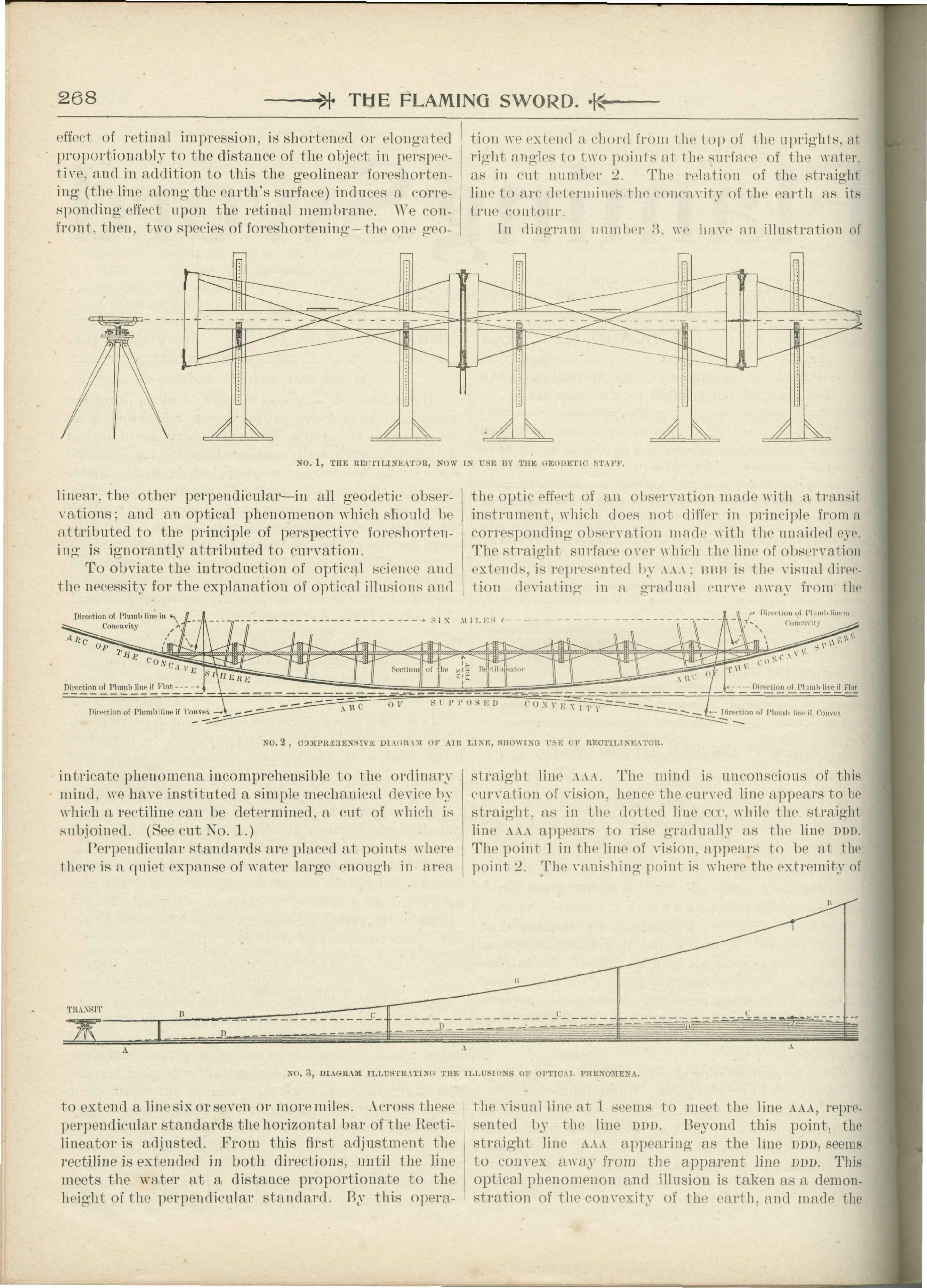
[Printed cut No. 1, captioned "THE RECTILINEATOR, NOW IN USE BY THE GEODETIC STAFF."]
To obviate the introduction of optical science and the necessity for the explanation of optical illusions and intricate phenomena incomprehensible to the ordinary mind, we have instituted a simple mechanical device by which a rectiline can be determined, a cut of which is subjoined. (See cut No. 1.)
[Printed cut No. 2, captioned "COMPREHENSIVE DIAGRAM OF AIR LINE, SHOWING USE OF RECTILINEATOR," with the label "Direction of Plumb line."]
Perpendicular standards are placed at points where there is a quiet expanse of water large enough in area to extend a line six or seven or more miles. Across these perpendicular standards the horizontal bar of the Rectilineator is adjusted. From this first adjustment the rectiline is extended in both directions, until the line meets the water at a distance proportionate to the height of the perpendicular standard. By this operation we extend a chord from the top of the uprights, at right angles to two points at the surface of the water, as in cut number 2. The relation of the straight line to arc determines the concavity of the earth as its true contour.
[Printed cut No. 3, captioned "DIAGRAM ILLUSTRATING THE ILLUSIONS OF OPTICAL PHENOMENA."]
In diagram number 3, we have an illustration of the optic effect of an observation made with a transit instrument, which does not differ in principle from a corresponding observation made with the unaided eye. The straight surface over which the line of observation extends, is represented by AAA; nnn is the visual direction deviating in a gradual curve away from the straight line AAA. The mind is unconscious of this curvation of vision, hence the curved line appears to be straight, as in the dotted line ccc, while the straight line AAA appears to rise gradually as the line mm. The point 1 in the line of vision, appears to be at the point 2. The vanishing point is where the extremity of the visual line at 1 seems to meet the line AAA, represented by the line nnn. Beyond this point, the straight line AAA appearing as the line DDD, seems to convex away from the apparent line DDD. This optical phenomenon and illusion is taken as a demonstration of the convexity of the earth, and made the basis of the illusory system of Copernican astronomy.
In the observation illustrated by diagram No. 3, we prove that a straight surface curves away from the line of vision, by the identical argument employed to prove the convexity of the earth. We can prove that a straight line bends four different ways, by the same argument used to sustain the convex theory of the earth.
- --
The source scans remain the record. This page preserves the periodical's argument and reported observations without presenting its conclusions as independently established results. The claims remain attributed to The Flaming Sword.
← Flaming Sword Archive
The Flaming Sword · Vol. 10, No. 12 · · PDF pp. 3-5