Extracted text
Editorial transcription, lightly normalized from the scan. Line-break hyphenation and unmistakable OCR errors have been repaired; the claims remain those of The Flaming Sword and The Salvator and Scientist.
[Article from The Salvator and Scientist]
The calculation as though each mountain stood upon the sea level, without the intervening mountainous country. At the altitude of 14,450 feet, in such case, the water horizon would be formed 150 miles distant, which may be verified by application of the usual formula of the square of the distance in miles, multiplied by 8 inches, giving the declination in inches; leaving 250 miles of surface beyond the horizon, with a declination of (250×250×8÷12 inches = ) 41,666 feet, or 7.89 miles, the required height of Mt. Rainier to be seen from the summit of Mt. Shasta on a convex earth!
Between the two mountains, however, is the Cascade mountain range and plateau, the average height being about 6,000 feet above the sea level. This would change the basis of calculation, placing the top of Mt. Shasta 8,450 feet above the arc of plateau, from which altitude the horizon would be 112 miles away. From the horizon to Mt. Rainier the distance would be 288 miles; the declination required for this distance is (288×288×8÷12 = ) 54,712 feet, or 10.36 miles, the required height of Mt. Rainier. Such a view is impossible over a convex arc 400 miles in length; it is possible because the earth is concave.
Capt. Glassford's Heliograph Experiment.
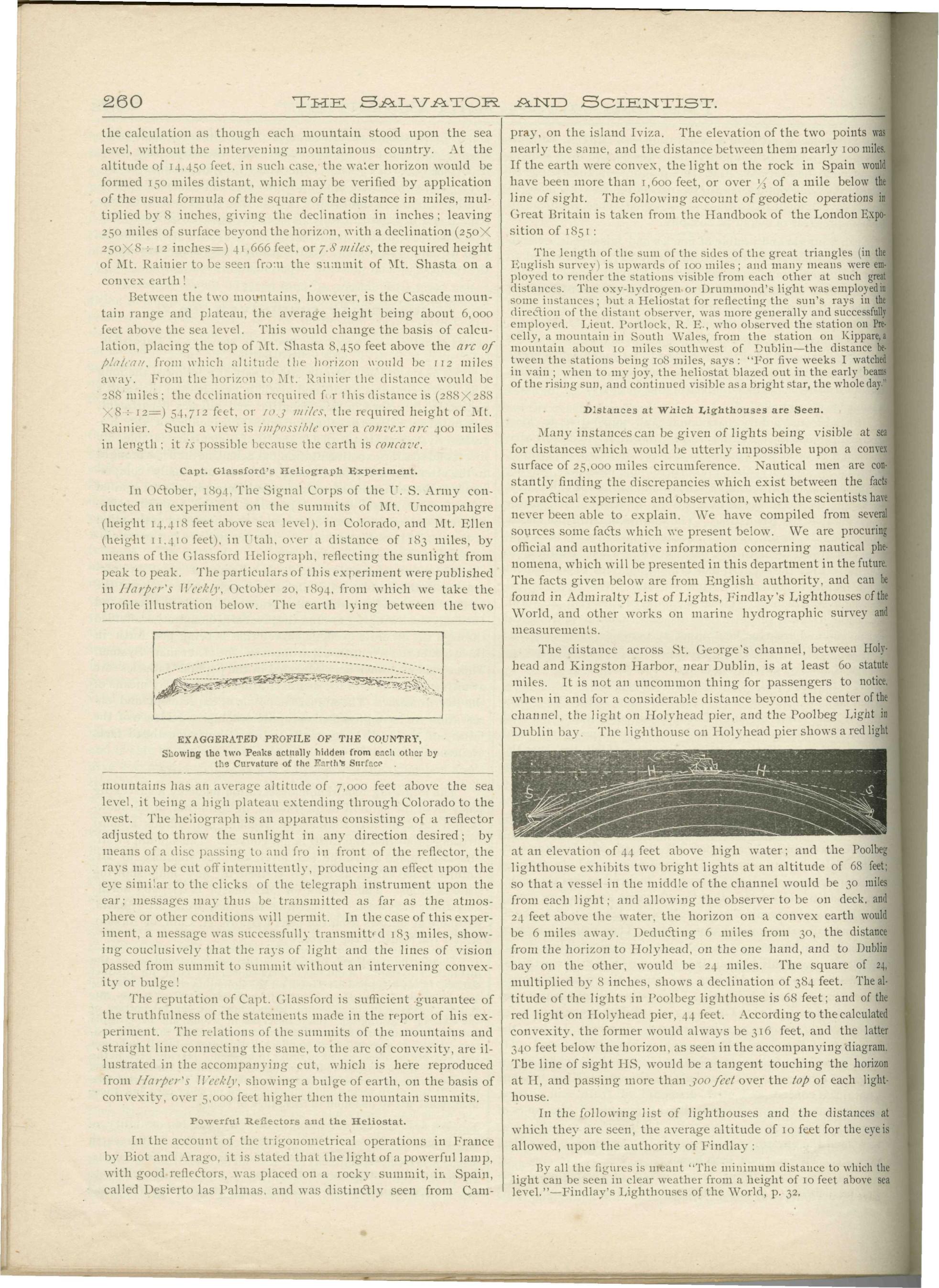
In October, 1894, The Signal Corps of the U.S. Army conducted an experiment on the summits of Mt. Uncompahgre (height 14,418 feet above sea level), in Colorado, and Mt. Ellen (height 11,410 feet), in Utah, over a distance of 183 miles, by means of the Glassford Heliograph, reflecting the sunlight from peak to peak. The particulars of this experiment were published in Harper's Weekly, October 20, 1894, from which we take the profile illustration below. The earth lying between the two mountains has an average altitude of 7,000 feet above the sea level, it being a high plateau extending through Colorado to the west.
The heliograph is an apparatus consisting of a reflector adjusted to throw the sunlight in any direction desired; by means of a disc passing to and fro in front of the reflector, the rays may be cut off intermittently, producing an effect upon the eye similar to the clicks of the telegraph instrument upon the ear; messages may thus be transmitted as far as the atmosphere or other conditions will permit. In the case of this experiment, a message was successfully transmitted 183 miles, showing conclusively that the rays of light and the lines of vision passed from summit to summit without an intervening convexity or bulge!
The reputation of Capt. Glassford is sufficient guarantee of the truthfulness of the statements made in the report of his experiment. The relations of the summits of the mountains and straight line connecting the same, to the arc of convexity, are illustrated in the accompanying cut, showing a bulge of earth, on the basis of convexity, over 5,000 feet higher than the mountain summits.
Powerful Reflectors and the Heliostat.
In the account of the trigonometrical operations in France by Biot and Arago, it is stated that the light of a powerful lamp, with good reflectors, was placed on a rocky summit, in Spain, called Desierto las Palmas, and was distinctly seen from Camprey, on the island Iviza. The elevation of the two points was nearly the same, and the distance between them nearly 100 miles. If the earth were convex, the light on the rock in Spain would have been more than 1,600 feet, or over ¼ of a mile below the line of sight. The following account of geodetic operations in Great Britain is taken from the Handbook of the London Exposition of 1851:
The length of the sum of the sides of the great triangles (in the English survey) is upwards of 100 miles; and many means were employed to render the stations visible from each other at such great distances. The oxy-hydrogen or Drummond's light was employed in some instances; but a Heliostat for reflecting the sun's rays in the direction of the distant observer, was more generally and successfully employed. Lieut. Portlock, R. E., who observed the station on Precelly, a mountain in South Wales, from the station on Kippare, a mountain about 10 miles southwest of Dublin—the distance between the stations being 108 miles, says: "For five weeks I watched in vain; when to my joy, the heliostat blazed out in the early beams of the rising sun, and continued visible as a bright star, the whole day."
Distances at Which Lighthouses are Seen.
Many instances can be given of lights being visible at sea for distances which would be utterly impossible upon a convex surface of 25,000 miles circumference. Nautical men are constantly finding the discrepancies which exist between the facts of practical experience and observation, which the scientists have never been able to explain.
The distance across St. George's Channel, between Holyhead and Kingston Harbor, near Dublin, is at least 60 statute miles. It is not an uncommon thing for passengers to notice, when in and for a considerable distance beyond the center of the channel, the light on Holyhead pier, and the Poolbeg Light in Dublin bay. The lighthouse on Holyhead pier shows a red light at an elevation of 44 feet above high water; and the Poolbeg lighthouse exhibits two bright lights at an altitude of 68 feet; so that a vessel in the middle of the channel would be 30 miles from each light; and allowing the observer to be on deck, and 24 feet above the water, the horizon on a convex earth would be 6 miles away. Deducting 6 miles from 30, the distance from the horizon to Holyhead, on the one hand, and to Dublin bay on the other, would be 24 miles. The square of 24, multiplied by 8 inches, shows a declination of 384 feet. The altitude of the lights in Poolbeg lighthouse is 68 feet; and of the red light on Holyhead pier, 44 feet. According to the calculated convexity, the former would always be 316 feet, and the latter 340 feet below the horizon, as seen in the accompanying diagram. The line of sight would be a tangent touching the horizon at H, and passing more than 300 feet over the top of each lighthouse.
In the following list of lighthouses and the distances at which they are seen, the average altitude of 10 feet for the eye is allowed, upon the authority of Findlay:
(By all the figures is meant "The minimum distance to which the light can be seen in clear weather from a height of 10 feet above sea level."—Findlay's Lighthouses of the World, p. 32.)
- --
The source scans remain the record. This page preserves the periodical's claims without presenting its conclusions as independently established results.
Source: The Flaming Sword (reprinted in The Salvator and Scientist) · Vol. 10, No. 11 · November 1896 · Physical PDF p. 20
The Flaming Sword · Vol. 10, No. 11 · Nov 1896 · PDF p. 20