Extracted text
Source-led transcription, lightly normalized from the page scans. Line-wrap hyphenation, mechanical spacing, and obvious scan whitespace have been repaired; historical claims remain attributed to The Flaming Sword.
Theodolite Tangents from the Standpoint of the Surveyor.
In all work of survey and geodetic operations (save in geodetic measurements with compensation rods) visual lines are employed; and from the assumption that visual lines are straight (modified only by refraction), they invariably conclude that the earth curvates downwards from the tangent visual line. We insist that it would be the wiser plan to first determine absolutely which way the earth curves, and from that tangible basis, determine the course or direction of the line of vision. The earth's surface is tangible, and can be tested; the lines of vision are intangible, and the direction and ratio of their curvation cannot be determined without an absolute demonstration of the earth's contour, from which the visual lines are divergent and tangent.
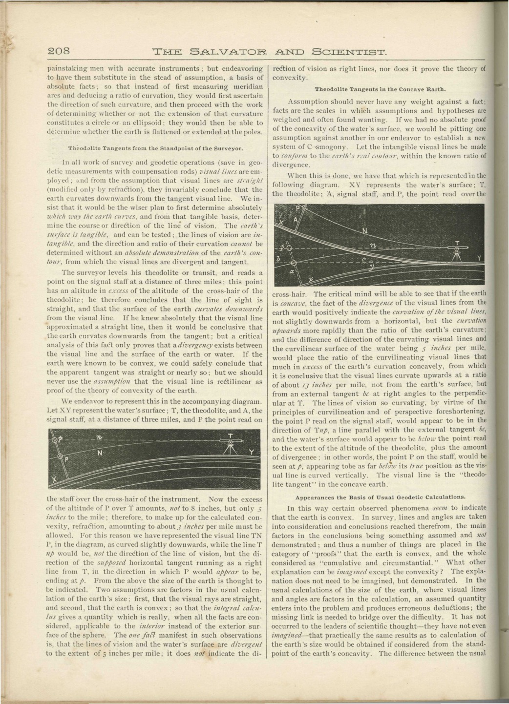
The surveyor levels his theodolite or transit, and reads a point on the signal staff at a distance of three miles; this point has an altitude in excess of the altitude of the cross-hair of the theodolite; he therefore concludes that the line of sight is straight, and that the surface of the earth curvates downwards from the visual line. If he knew absolutely that the visual line approximated a straight line, then it would be conclusive that the earth curvates downwards from the tangent; but a critical analysis of this fact only proves that a divergence exists between the visual line and the surface of the earth or water. If the earth were known to be convex, we could safely conclude that the apparent tangent was straight or nearly so; but we should never use the assumption that the visual line is rectilinear as proof of the theory of convexity of the earth.
We endeavor to represent this in the accompanying diagram. Let X Y represent the water's surface; T, the theodolite, and A, the signal staff, at a distance of three miles, and P the point read on the staff over the cross-hair of the instrument. Now the excess of the altitude of P over T amounts, not to 8 inches, but only 5 inches to the mile; therefore, to make up for the calculated convexity, refraction, amounting to about 3 inches per mile must be allowed. For this reason we have represented the visual line TN P, in the diagram, as curved slightly downwards, while the line T tip would be, not the direction of the line of vision, but the direction of the supposed horizontal tangent running as a right line from T, in the direction in which P would appear to be, ending at p. From the above the size of the earth is thought to be indicated. Two assumptions are factors in the usual calculation of the earth's size; first, that the visual rays are straight, and second, that the earth is convex; so that the integral calculus gives a quantity which is really, when all the facts are considered, applicable to the interior instead of the exterior surface of the sphere. The one fail manifest in such observations is, that the lines of vision and the water's surface are divergent to the extent of 5 inches per mile; it does not indicate the direction of vision as right lines, nor does it prove the theory of convexity.
Theodolite Tangents in the Concave Earth.
Assumption should never have any weight against a fact; facts are the scales in which assumptions and hypotheses are weighed and often found wanting. If we had no absolute proof of the concavity of the water's surface, we would be pitting one assumption against another in our endeavor to establish a new system of Cosmogony. Let the intangible visual lines be made to conform to the earth's real contour, within the known ratio of divergence.
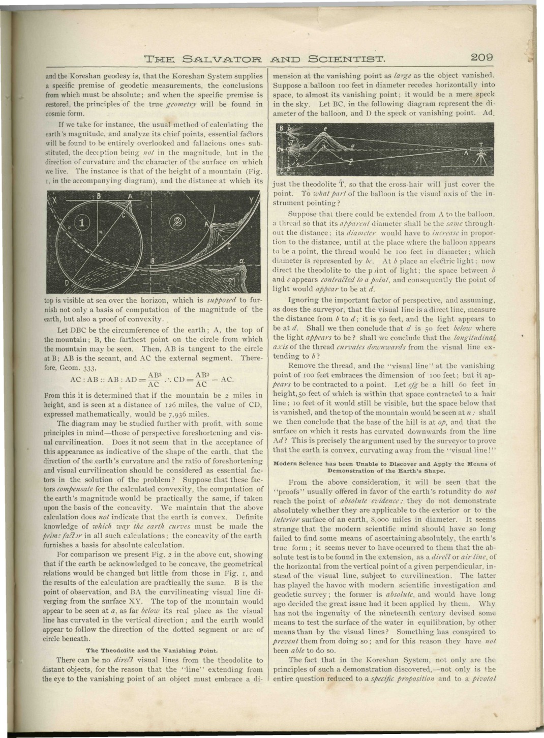
When this is done, we have that which is represented in the following diagram. XV represents the water's surface; T, the theodolite; A, signal staff, and P, the point read over the cross-hair. The critical mind will be able to see that if the earth is concave, the fact of the divergence of the visual lines from the earth would positively indicate the curvation of the visual lines, not slightly downwards from a horizontal, but the curvation upwards more rapidly than the ratio of the earth's curvature; and the difference of direction of the curvating visual lines and the curvilinear surface of the water being 5 inches per mile, would place the ratio of the curvilineating visual lines that much in excess of the earth's curvation concavely, from which it is conclusive that the visual lines curvate upwards at a ratio of about 13 inches per mile, not from the earth's surface, but from an external tangent be at right angles to the perpendicular at T. The lines of vision so curvating, by virtue of the principles of curvilineation and of perspective foreshortening, the point P read on the signal staff, would appear to be in the direction of Tnp, a line parallel with the external tangent be, and the water's surface would appear to be below the point read to the extent of the altitude of the theodolite, plus the amount of divergence; in other words, the point P on the staff, would be seen set p, appearing to be as far below its true position as the visual line is curved vertically. The visual line is the "theodolite tangent"in the concave earth.
Appearances the Basis of Usual Geodetic Calculations. In this way certain observed phenomena seem to indicate that the earth is convex. In survey, lines and angles are taken into consideration and conclusions reached therefrom, the main factors in the conclusions being something assumed and not demonstrated; and thus a number of things are placed in the category of "proofs" that the earth is convex, and the whole considered as "cumulative and circumstantial." What other explanation can be imagined except the convexity? The explanation does not need to be imagined, but demonstrated. In the usual calculations of the size of the earth, where visual lines and angles are factors in the calculation, an assumed quantity enters into the problem and produces erroneous deductions; the missing link is needed to bridge over the difficulty. It has not occurred to the leaders of scientific thought—they have not even imagined—that practically the same results as to calculation of the earth's size would be obtained if considered from the standpoint of the earth's concavity. The difference between the usual and the Koreshan geodesy is, that the Koreshan System supplies a specific premise of geodetic measurements, the conclusions from which must be absolute; and when the specific premise is restored, the principles of the true geometry will be found in cosmic form.
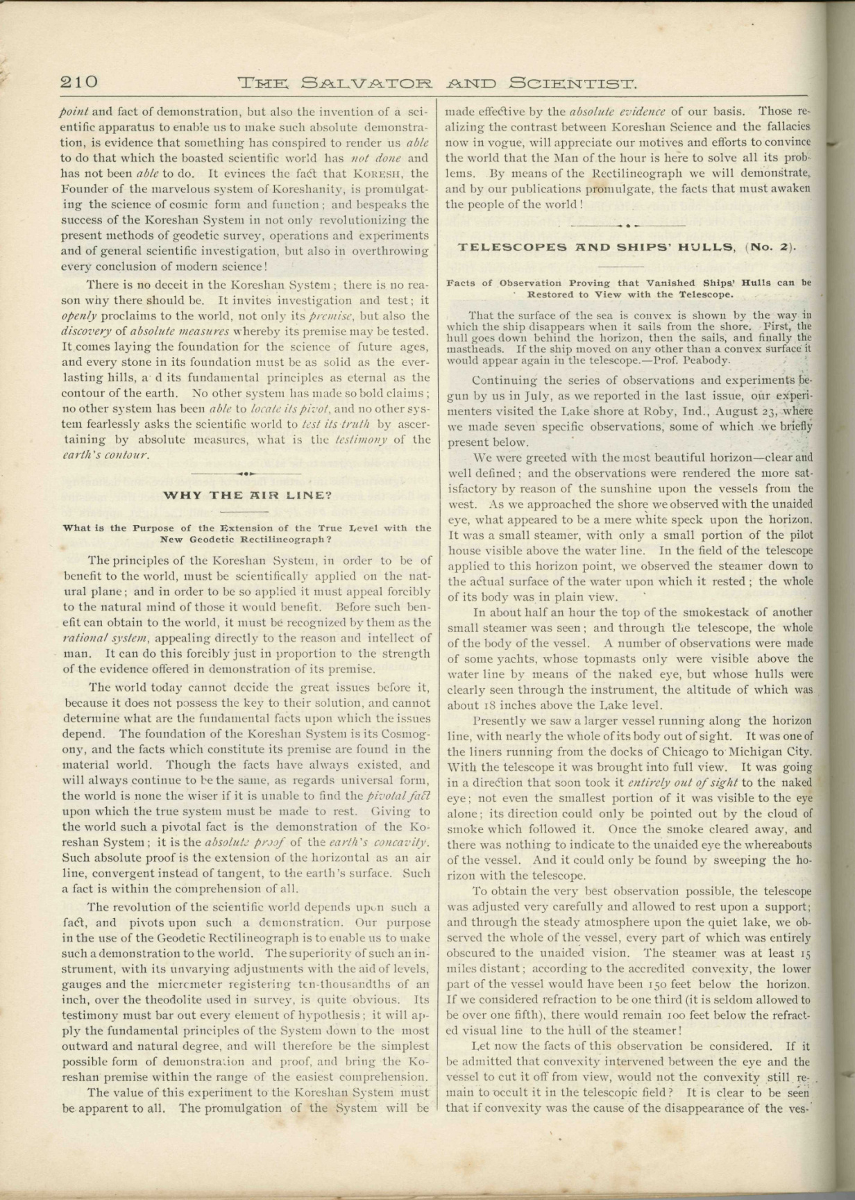
If we take for instance, the usual method of calculating the earth's magnitude, and analyze its chief points, essential factors will be found to be entirely overlooked and fallacious ones substituted, the deception being not in the magnitude, but in the direction of curvature and the character of the surface on which we live. The instance is that of the height of a mountain (Fig. i, in the accompanying diagram), and the distance at which its top is visible at sea over the horizon, which is supposed to furnish not only a basis of computation of the magnitude of the earth, but also a proof of convexity.
Let DBC be the circumference of the earth; A, the top of the mountain; B, the farthest point on the circle from which the mountain may be seen. Then, AB is tangent to the circle at B; AB is the secant, and AC the external segment. Therefore, Geom. 333,
AB2 AB'i A C; A B;; A B; A D = A C. •. CD = ^ ~ AC. From this it is determined that if the mountain be 2 miles in height, and is seen at a distance of 126 miles, the value of CD, expressed mathematically, would be 7,936 miles.
The diagram may be studied further with profit, with some principles in mind—those of perspective foreshortening and visual curvilineation. Does it not seem that in the acceptance of this appearance as indicative of the shape of the earth, that the direction of the earth's curvature and the ratio of foreshortening and visual curvilineation should be considered as essential factors in the solution of the problem? Suppose that these factors compensate for the calculated convexity, the computation of the earth's magnitude would be practically the same, if taken upon the basis of the concavity. We maintain that the above calculation does?iot indicate that the earth is convex. Definite knowledge of 'which way the earth curves must be made the prim; fail)r in all such calculations; the concavity of the earth furnishes a basis for absolute calculation.
For comparison we present Fig. 2 in the above cut, showing that if the earth be acknowledged to be concave, the geometrical relations would be changed but little from those in Fig. 1, and the results of the calculation are practically the same. B is the point of observation, and BA the curvilineating visual line diverging from the surface XY. The top of the mountain would appear to be seen at a, as far below its real place as the visual line has curvated in the vertical direction; and the earth would appear to follow the direction of the dotted segment or arc of circle beneath.
The Theodolite and the Vanishing Point. There can be no direct visual lines from the theodolite to distant objects, for the reason that the "line" extending from the eye to the vanishing point of an object must embrace a dimension at the vanishing point as large as the object vanished. Suppose a balloon 100 feet in diameter recedes horizontally into space, to almost its vanishing point; it would be a mere speck in the sky. Let BC, in the following diagram represent the diameter of the balloon, and I) the speck or vanishing point. Ad. just the theodolite T, so that the cross-hair will just cover the point. To what part of the balloon is the visual axis of the instrument pointing?
Suppose that there could be extended from A to the balloon, a thread so that its apparent diameter shall be the same throughout the distance; its diameter would have to increase in proportion to the distance, until at the place where the balloon appears to be a point, the thread would be 100 feet in diameter; which diameter is represented by be. At b place an electric light; now direct the theodolite to the point of light; the space between b and c appears contracted to a point, and consequently the point of light would appear to be at d.
Ignoring the important factor of perspective, and assuming, as does the surveyor, that the visual line is a direct line, measure the distance from b to d; it is 50 feet, and the light appears to be at d. Shall we then conclude that d is 50 feet below where the light appears to be? shall we conclude that the longitudinal axis of the thread curvates downwards from the visual line extending to b?
Remove the thread, and the "visual line" at the vanishing point of 100 feet embraces the dimension of 100 feet; but it appears to be contracted to a point. Let efg be a hill 60 feet in height,50 feet of which is within that space contracted to a hair line; 10 feet of it would still be visible, but the space below that is vanished, and the top of the mountain would be seen at u; shall we then conclude that the base of the hill is at op, and that the surface on which it rests has curvated downwards from the line Ad? This is precisely the argument used by the surveyor to prove that the earth is convex, curvating away from the "visual line!"
Modern Science has been Unable to Discover and Apply the Means of Demonstration of the Earth's Shape.
From the above consideration, it will be seen that the "proofs" usually offered in favor of the earth's rotundity do not reach the point of absolute evidence; they-do not demonstrate absolutely whether they are applicable to the exterior or to the interior surface of an earth, 8,000 miles in diameter. It seems strange that the modern scientific mind should have so long failed to find some means of ascertaining absolutely, the earth's true form; it seems never to have occurred to them that the absolute test is to be found in the extension, as a direct or air line, of the horizontal from the vertical point of a given perpendicular, instead of the visual line, subject to curvilineation. The latter has played the havoc with modern scientific investigation and geodetic survey; the former is absolute, and would have long ago decided the great issue had it been applied by them. Why has not the ingenuity of the nineteenth century devised some means to test the surface of the water in equilibration, by other means than by the visual lines? Something has conspired to prevent them from doing so; and for this reason they have not been able to do so.
The fact that in the Koreshan System, not only are the principles of such a demonstration discovered,—not only is the entire question reduced to a specific proposition and to a pivotal point and fact of demonstration, but also the invention of a scientific apparatus to enable us to make such absolute demonstration, is evidence that something has conspired to render us able to do that which the boasted scientific world has not done and has not been able to do. It evinces the fact that Koresh, the Founder of the marvelous system of Koreshanity, is promulgating the science of cosmic form and function; and bespeaks the success of the Koreshan System in not only revolutionizing the present methods of geodetic survey, operations and experiments and of general scientific investigation, but also in overthrowing every conclusion of modern science! There is no deceit in the Koreshan System; there is no reason why there should be.
It invites investigation and test; it openly proclaims to the world, not only its premise, but also the discovery of absolute measures whereby its premise may be tested. It comes laying the foundation for the science of future ages, and every stone in its foundation must be as solid as the everlasting hills, and its fundamental principles as eternal as the contour of the earth. No other system has made so bold claims; no other system has been able to locate its pivot, and no other system fearlessly asks the scientific world to test its truth by ascertaining by absolute measures what is the testimony of the earth's contour.
Source boundary repaired from the continuation on PDF p. 18. The transcription ends before the separately headed “Why the Air Line?” article; claims remain those of The Flaming Sword.
Vol. 10, No. 9 · Sep. 1896 · PDF pp. 16–18
- --
The source scans remain the record. This page preserves the periodical's argument and reported observations without presenting its conclusions as independently established results. The claims remain attributed to The Flaming Sword.
← Flaming Sword Archive
The Flaming Sword · Vol. 10, No. 9 · Sep 1896 · PDF pp. 16–18